
This hike is about so much more than the highest point achieved - Mont d'Orzeires (No. 282 at 1155 metres) - as its real highlights are the amazing caves of Grotte de l'Orbe ... and a gorgeous forest trail of course. But what else would one expect? It's the magnificent Jura!
This hike started at Vallorbe - sandwiched below Mont d'Or and Dent de Vaulion on the diagram below - and headed southwest up the Orbe valley to the Source de l'Orbe, before cutting over the mountain pass to Mont d'Orzeires, and then down the western side of Lac Brenet to Les Charbonnières and finally around the southern end of the lake to Le Pont. It promised to be a fabulous ramble ... and that was exactly what it was.

Interpretation panel at Le Pont - from where we started the hike.
We drove over the first couple of ridges of the Jura to the Vallée du Joux town of Le Pont - where we parked the car just near the railway station, and checked-out all of the signage and interpretation panels whilst waiting for our train. We had planned our walk to start in Vallorbe and finish in Le Pont, so the "little red train" option proved to be just perfect. A train runs from Le Pont to Vallorbe every hour - at half past the hour - so we made sure we were there ready for the 10:30 "express".

One of the Vallorbe- Vallée du Joux trains pulling in to Le Pont.
The train took us up the eastern side of Lac Brenet, into a tunnel under the mountain below Les Agouilles, and then down the eastern side of the Orbe valley under the steep slopes of the Côte de la Dent - with the jagged, tooth-like peak of Dent de Vaulion towering high above to the south. Not that we could see it. The day was completely overcast, and, with the cloud layer down to about 1,000 metres, there was hardly a Jura peak in sight. Luckily we'd hiked to the top of Dent de Vaulion a couple of times before, and had already enjoyed great views of all over this part of the Jura from its summit, so weren't too disappointed. (You can read about the Dent de Vaulion hikes here.)
Despite the limited views, the train ride was still a real treat (worth doing just for the fun of it), and after taking a wide loop around the eastern end of the town, soon pulled into Vallorbe. It was about 10:45.
We stepped-out of our carriage and headed out to the front of the station - from where we started our walk, and where we took advantage of the first (of many) excellent trail signs. This would have to be one of the best sign-posted walks we'd encountered anywhere in the Jura. It would be hard to get lost.

At the grand entrance to the railway station at Vallorbe (807 metres).
Up behind the station - hidden somewhere beyond the high cliffs and tall forests of the Côte de Pralioux - was Mont d'Or - another favourite Jura landmark, which we hiked to in October 2013. (You can read about that hike here). Looking southwest down the road towards where we were heading today, the town's other major landmark - Dent de Vaulion was completely shrouded in cloud. But, no matter, we could still see our first destination of the day - the reculée de l'Orbe - the end of the valley from where the Orbe river emerges from the base of the mountains. In the photo below one can just make-out the summit of Crêt des Alouettes (1052m - at the top left) and, down to the right, the limestone cliffs above the Source de l'Orbe. Our route would take us up to these cliffs, then up the slopes in the far right of the photo - and over the Col du Mont d'Orzeires to Mont d'Orzeires (hidden in the clouds in this photo), and then down through the forests and farmland back to Le Pont. The sign said it was a 2 hour 35 minute walk, but we planned to make lots of stops and take lots of photos, so were planning on being on the trail for more like four hours. This countryside is too beautiful to rush through.

Heading southwest from the Vallorbe railway station
towards the Source de l'Orbe.
towards the Source de l'Orbe.
The first section of the trail was along the edge of the roads that lead southwest out of the town, but - at the Sentier et Etang du Grand Morcel - the trail dropped down to the river and a gorgeous riverside walking track.

Heading down to L'Orbe River.
Grand Morcel is a nature reserve set aside to protect wetlands adjacent to the Orbe River - which have formed in an ancient bend in the river over thousands of years. The walk trail skirts the river, marshlands and the (pond) that is being protected and maintained just below the town. The reserve dates back to 2006 - when a group of local foresters initiated a project to provide better access and protection for the wetlands. This was further enhanced in 2008 - by members of the Vallorbe community. We crossed a small footbridge over the Orbe to reach the Grand Morcel, and then turned right (southwest) to follow the walk trail that ran alongside the river. It truly is one of the best things to do in life - to hike alongside a running river, bubbling brook or singing stream. It's nature's music for trail travelers and trekkers.

Hiking alongside the Orbe River towards the Source de l'Orbe.

Cutting through a patch of forest near Le Montagnat.
After cutting through a patch of forest at Le Montagnat, and a a section of wetlands at La Pousserde, we reached a small hydro-electricity station - where the trail left the river and joined the adjacent road. Once again there was a generously adorned signpost with bright yellow signs pointing in all directions - including towards the Grottes de l'Orbe - our first milestone for the day.

All roads lead to Le Pont.
By now we were approaching the steep gorge at the upper end of the Orbe valley - and from which the Orbe River emerges from under the mountains towering above. Off to our left we could see a pipeline and power lines that transfer the water and electricity up and down this section of the Jura. As anyone who has ever visited the Grotte de l'Orbe can testify - there's a mountain of power in that water as it explodes out of the cave from its deep subterranean sources. It's an incredible sight to see, and well worth the trip to the Grotte.

Power lines and water pipes coming down the mountainside
from Crêt des Alouettes (1052m).
from Crêt des Alouettes (1052m).
A little further up the valley we reached Vallorbe La Dernier (759m), where the river really starts to froth and bubble, and where there is a large car-park for day-trippers coming to visit the famous cave and Source de l'Orbe. We'd parked here just the previous day - when we'd come up to Grotte de l'Orbe to check-out the cave and see the Source of the Orbe for ourselves. We'd driven past here on many, many occasions, and finally had got around to taking the time to come back for a specific visit. It really was an amazing experience - which we'd thoroughly recommend to everyone. Perhaps we'll write a blog entry about it sometime soon and post it in a special section on Jura Mountain Rambling.

Trail sign at Vallorbe La Dernier.
We turned left - up the blue-signposted Chemin de la Résurgence - and made our way alongside the last (first?) section of the Orbe. It may be the last part of this riverside trail, but it's also the very best - as the river is quite a torrent here - tumbling over rocks and rapids, and (at this time of the year), beautifully framed by the yellow, brown and green colours of autumn. Needless to say, we stopped quite often to enjoy the views, and to take lots of photos.

The headwaters of the Orbe River near Grotte de L'Orbe.

Weathered, eroded and dissolved: a limestone boulder on the banks of the Orbe
with intricate markings like a giant ancient rune.

Gorgeous setting for a cabin on the banks of the Orbe - just below la Grotte.
Eventually we reached the end of this section of the trail - where one had to make a choice of either heading just another 100 metres further ahead - to the entrance of the cave (the Grotte) - or taking the trail that crossed the river and headed west up towards the Grotte aux Fées (Cave of Fairies).

Signpost near the Grottes de l'Orbe at the turn-off to Grotte aux Fées.

(In the distance) the bridge over the Orbe River just below Grotte de l'Orbe.
Although it's been forming for millions of year, and probably been known about for centuries, it was first properly explored in 1893 - when early speleologists, in primitive diving suits, first ventured into its dark depths and frigid waters. Taking advantage of much more modern equipment, the cave was further substantially explored and mapped in 1961. Finally, after much (and excellent) preparatory work, it was opened to the public in 1974, and has since been viewed by thousands of visitors. It really is quite a spectacle.

Inside the cavernous Grotte de l'Orbe.

An underground pool in the Grotte de l'Orbe.
Although the cave contained many amazing features, the real highlight (for us at least), was seeing the headwaters of the Orbe River bursting out of the floor of the cave deep inside the mountain. The water surges-up - frothing and bubbling like boiling water in a giant witches cauldron - from the floor of the cave, and then rushes down the Grotte, in and out of tunnels and cavities, before spilling-out into the river at the top of the Orbe Valley. There just aren't enough superlatives to do justice to the spectacle.

The Orbe River emerging from the Grotte de l'Orbe.

An interpretation panel inside the Grotte de l'Orbe showing the valley and surrounding countryside. Number 1 marks the Grotte; and number 2 the Grotte aux Fées. Our Jura summit destination - Mont d'Orzeires - is at top right, and our hike's end point - the Lac de Joux - is in the far distance.

Another interpretation panel outside the Grotte, showing the main features of the cirque de la source de l'Orbe: including the Source and Grotte de l'Orbe (2); and the Grotte aux Fées (5) - our next destination.
Of course, we bypassed the cave today, and instead headed across the bridge towards the Grotte aux Fées - the cave of the fairies , which we were keen to explore by ourselves. Not surprisingly, we stopped at the bridge for quite awhile, mesmerized by the rushing water and struck by the beauty of the place. The trees that surrounded us carried every possible shade of green.

The bridge over the Orbe River just below the Grotte de l'Orbe.

The Orbe emerging from the cave and cliffs at the head of the Orbe valley.
The trail immediately swung west - up the steep western slopes of the Orbe Valley. The trail was littered with millions of brown autumn leaves that had tumbled out of the surrounding deciduous forest (mainly beech), and was thus an absolute delight to shuffle and drag our boots through the deeper accumulations.

Heading up the slopes towards Grotte aux Fées.
The trail zigged and zagged its way up the slope through a series of switchbacks; and up and over rocky outcrops and other obstacles before momentarily flattening-out near the entrance to the Grotte aux Fées.

A section of the trail just below the entrance to the Grotte aux Fées.

Approaching the entrance to the Grotte aux Fées.
There are two sections (and openings) to the Fairies' Cave - appropriately called the Large and the Small - and, from what I know about them, the Small is probably best left only to experienced cavers carrying all of the right gear. So we decided to limit our visit just to exploring the Large cave - la Grand Grotte au Fées. From the information panel just inside the cave entrance, we learned that it wound its way into the mountain for about 180 metres - with a chimney-type feature at its very end. Unlike the Grotte de l'Orbe, this cave is not set-up for visitors. There are no lights, no paths, no "watch your head" warning signs. Nothing. Just pitch darkness (the "can't see your hand in front of your face" type), and lots of wet, slippery rocks to fall over. This was going to be fun.

Sign at the entrance to Grotte aux Fées.
We planned to see if we could make it all the way through to the end - to the chimney, so we pulled on our head-torches and set-off into the cave. It was relatively easy-going through the first section, then it required a bit of scrambling up rock-strewn slopes, and around and through some boulder fields that were strewn with blocks of rock that had fallen from the cave roof above. In some sections the roof was many, many metres above us, while in others we had to stoop-down to be able to continue further and deeper into the cave. Eventually we reached the chimney, where we stayed just a few minutes before making the return trip back to the entrance. Although it had some nice iridescent and silvery features among the rocks around us, or shining off the roof of the cave in some places, it had very few of the amazing cave features that filled the Grotte de l'Orbe.

Checking-out some "ancient rock art" graffiti in the cave.

Approaching one of the narrower sections of the cave.
Getting out was easier than getting in (isn't that always the way?), and we were soon back at the cave entrance and packing our head-torches away. The trip into the cave was a great addition to this hike, so I'd recommend anyone doing this walk - from Vallorbe to Le Pont (or vice versa) - to make sure they pack their headlamps or some other kind of torch.

Looking out from the entrance of the Grotte aux Fées.
Leaving the Grotte aux Fées, we headed north up the steep slope that took us to the road that heads over the Col du Mont d'Orzeires between Vallorbe and Le Pont. Although rimmed with exposed limestone cliffs and rockfaces, the trail was once again filled with fallen leaves from the leaf-thinning forest canopy above us.

The leaf-littered trail on the north side of the Cirque de l'Orbe.
Once we reached the road, we followed the direction of the yellow trail signs and turned left (in a westerly direction). For a hundred metres or so, we had to walk along the road - as there was a drop-off cliff on our left and a vertical rockface on our right and there was nowhere else to go. This road had been literally carved through the mountain here.

Signpost at the point where the trail leaves the forest and joins the road above Grotte aux Fées with details about the area's protected status.
Fortunately the trail didn't stay on the road for too long, and we were soon re-entering the forest and gaining the altitude we needed to pass over the col - a kilometre or so ahead of us. At first, the trail followed the contour, and so was relatively easy going, but then it began cutting across the contours as we gained the necessary height to reach the col. At this point in time, the weather also took a turn for the worse - as it began to drizzle with rain - so we stopped to pull-on our rain jackets and pack-covers before continuing higher up the mountainside.

Heading into the forest after leaving the road above Grotte aux Fées.
Despite the deteriorating weather conditions, we were having fun. This was a lovely section of the trail, even though it intersected with the Vallorbe - Le Pont road one more time, and (because it was relatively close to the road in some sections), meant that the tranquility of the forest was disturbed from time to time by the sounds of passing cars. The section of trail after the second road crossing was again a delight - and relatively easy going along a long gentle traverse.

The (well-marked) section of trail near a place on the topographic map
called Gouille à l'Ours (Puddle of the Bears).

The magnificent trail on the northern side of the Col du Mont d'Orzeires.
At about 13:00 we intersected the col road for the third time - just north of the Chalet du Mont d'Orzeires - which was enveloped in cloudy mist, but filled with diners enjoying a wintery lunch of fondue or other such Swiss mountain delights. We took a long, lingering look at the warm diners through the chalet windows, and then continued on our way - back across the road again to the west, and then the southwest towards the highest point of Mont d'Orzeires.

Not surprisingly, no-one was choosing to dine al fresco
under the umbrellas at the Chalet du Mont d'Orzeires.

Trail sign at Chalet du Mont d'Orzeires (1029m).
The Chalet du Mont d'Orzeires is not only a popular Jura restaurant, but it's also the entrance to Jura Parc - or Parc Jurassien (or Jurassic Park) - another great place to visit up here in the Jura Mountains.

Park sign near the entrance to Juraparc.
It was shrouded in cloud today, so visitors probably wouldn't have seen much, but on previous visits we've loved watching the park's resident wolf pack running all around the rocks and forest, or lazing on rocky outcrops in the warmth of the sun. The wolves were introduced to the park in 2002. The park also has bison (introduced in 1987), bears (in 2002), Prjevalski horses, and lynx - however we've never see the latter whenever we'd been there.

A wolf which I photographed in Juraparc a couple of years previously.

One of the Juraparc bears.
Of course, we bypassed the park on this occasion and headed along the trail west of the road and away from the Col du Mont d'Orzeires. Now approaching the highest point on our planned route, the clouds were really closing-in and visibility was restricted to less than 50 metres. Luckily this didn't matter, as there were few views to be had - due to the dense forest - and the white-out certainly added to the atmosphere of the walk. The forest was strangely silent, except for the sound of water dripping from the trees above, but it was filled with the colours of autumn and visual delights of mosses and fungi and other fabulous forest life half-hidden in the deep leaf litter all around us.

The delightful colours of autumn on the trail near Mont d'Orzeires.

A giant bracket fungi on a fallen log alongside the trail.
About half a kilometre southwest of the chalet and road we approached the highest point of Mont d'Orzeires. With dense forest obscuring any views from the summit (and cloud adding to that while we were there), it's not surprising that this is not a popular destination for regular hikers in this neck of the Jura woods. There was no track to the summit, so we had the "bush-bash" our way through the scrub, and scramble our way over rocks and fallen logs to reach the top of the mountain. Like many other of the lesser-known or visited Jura peaks, the summit of Mont d'Orzeires is quite unspectacular, but nonetheless, it is one, and worth celebrating. We reached the top (1155 metres) at about 13:30, and immediately dropped our packs and broke-out our trail lunch, and thermoses of hot tea. The latter were a real comfort as we stood on the mountain-top amidst the surrounding cloud and drizzling rain.

Enjoying a cup of hot tea at the top of Mont d'Orzeires.
We left the hilltop at about 14:00, and crashed our way back down the western slope from the summit to re-find the trail that would take us through to Les Charbonnières and Le Pont. Fortunately it was relatively easy to re-locate, and we were soon on our way - heading further southwest away from the Col du Mont d'Orzeires and hill-top of the same name. Although now "on our way home", there were still a few kilometres ahead of us, and much to see.
We came across an ancient dry-stone wall, which was now derelict, tumbled-down and covered with moss. It told a story of an alpine pasturage that was now long gone and reclaimed by the forest, and so we hung around for awhile soaking-up the atmosphere and taking photographs. It really was a lovely place.

The remnants of an old dry-stone wall deep in the forest.

Chilling in the forest near Mont d'Orzeires.
Once again, this section of the trail was easy-going, and gorgeous, and we reveled in the moody atmosphere created by the cloudy conditions.

On the trail southwest of Mont d'Orzeires.
Refueled and refreshed from our lunch stop, we made good time over the remaining part of the walk - which also happened to be virtually all downhill back to Le Pont. Before we knew it, we reached the edge of the forest and, after passing through one of those (always unexpected) trail turnstiles, we entered an alpine pasturage that skirted the western side of the forest marked Pât de l'Epine on the topographic map.

Leaving the forest via the trail turnstile.

Taking the last steps in the forest before hitting the road
through the alpine pasturage.
through the alpine pasturage.
Now walking on a sealed farm road, we soon reached and passed-by the turn-off to the alpine homestead Le Grandes Cernies (1125m), and soon after that, walked up to and past the Petites Cernies homestead.

Le Petites Cernies homestead.
A little further down the road we reached another dwelling - L'Epine - where we passed through the farmyard in front of the house and continued on our way down the valley. Off to our left we were beginning to see - through breaks in the cloud - glimpses of the next (more easterly) Jura ridgeline across the Vallée du Joux - with the Haut du Mollendruz the highest immediate landmark across the valley.

Glimpses of the Haut du Mollendruz ridgeline across the Vallée du Joux.
We stopped for awhile to check-out, and photograph a mob of cows that were in an adjacent field, but by now we could see Les Charbonnières and Le Pont through the clouds below us, and were keen to finish-off this hike.

Capturing cows on camera near L'Epine.

Lis' close-up of one of the cows at L'Epine.
Our next way-point was at an intersection near a place called Les Frênes ("the Ash trees" - although there were certainly none left in the landscapes around here now). Roads headed off in different directions - to various homesteads called La Palestine, Haut Des Prés, and La Corne. But we weren't headed for any of these, and instead turned south towards the main road between Les Charbonnières and Mouthe - at a place called Les Replats (1051m). Just nearby was an old moss and lichen encrusted cement milestone marking the 42nd kilometre on the road from Lausanne to Mouthe. It was obviously a more important route between Switzerland and France in days gone by.

Trail sign alongside the road at Les Replats.
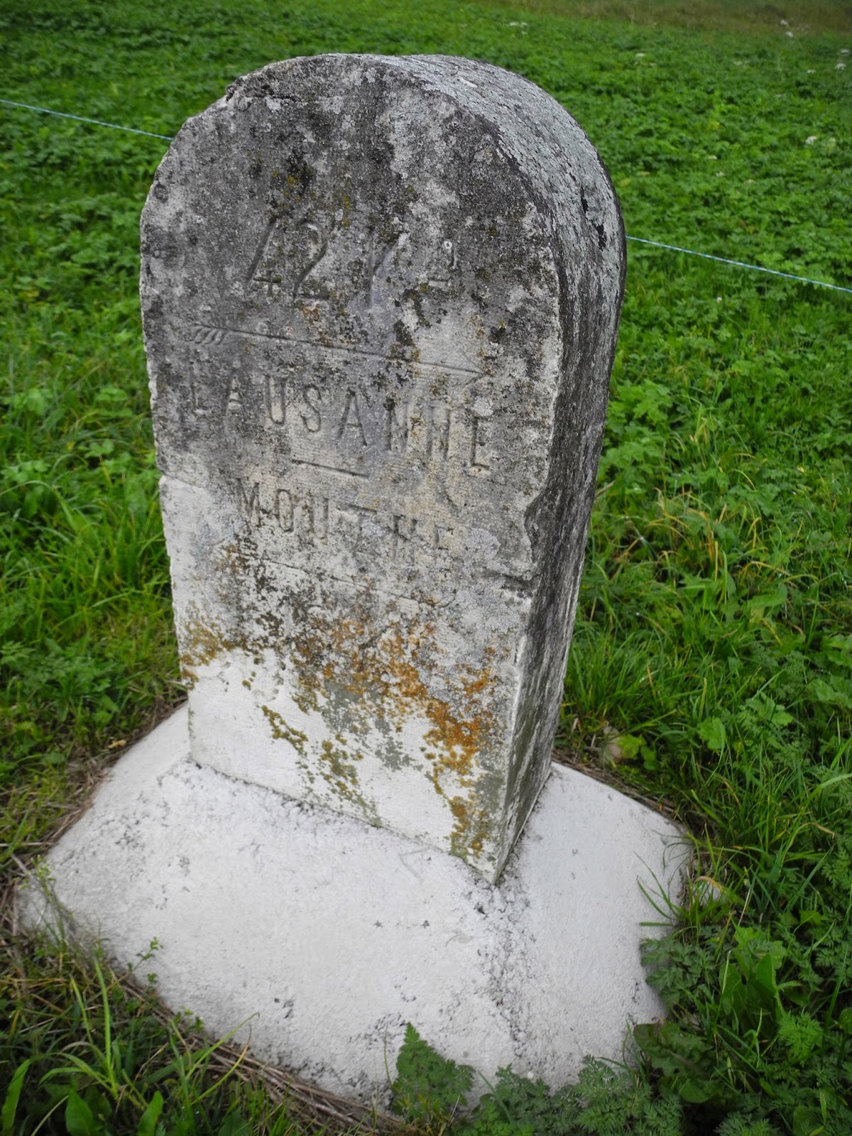
Old Lausanne - Mouthe road milestone near Les Replats.
Across the road was a lonely-looking cemetery, on the wall of which was a yellow trail direction sign beckoning us to skirt around the landmark, before cutting through the fields towards the two towns below. A hundred metres or so further to the southwest, we reached another pair of yellow trail signs signalling yet another change in direction - which we duly followed down the hil. There, on the outskirts of the town was another trail-sign - marked Les Charbonnières 1024m - at which point we enetered the outskirts of the town and began the final part of our hike through its streets.

Trail sign on the outskirts of Les Charbonnières.

Walking down the Route de Mouthe through Les Charbonnières.
Eventually we reached the centre of the town - near the local church - where the Mouthe road intersected with the road that runs around the northern side of Lac de Joux southwest of Le Pont. We stopped just long enough to read all of the signs, and take a couple of photographs, and then turned east along the last part of the trail along the southern side of Lac Brenet. We stopped a couple of times to read the interpretation panels that have been placed along the route (actually for a round-the-lake walk called the "Tour du Lac"), and to take a few last photographs.

The centre of Les Charbonnières.

Detail from one of the information panels
- of Lac Brenet and Dent de Vaulion.
- of Lac Brenet and Dent de Vaulion.

Looking across Lac Brenet towards Les Agouillons
and the distant tip of Dent de Vaulion.
and the distant tip of Dent de Vaulion.

Les Agouillons and adjacent hills above Le Pont
- from the southern shores of Lac Brenet.
- from the southern shores of Lac Brenet.
The last part of the trail cut across the flats south of Lac Brenet, and then crossed the Le Pont - Les Charbonnières road before passing under the railway line to the very edge of Lac de Joux. After a short walk alongside the northwest shore of the lake, we found ourselves back at the car-park in Le Pont. It was 15:00 - about four hours from when we'd left the railway station in Vallorbe. It had been a great walk ... and thoroughly recommended.

Passing under the railway near Le Pont.

Lac de Joux and Le Pont.

The trail sign in Le Pont says 2 hours and 30 minutes to Vallorbe - but we'd managed to make it last for four fantastic hours - with caves and peaks and many other nooks and crannies to explore along the way.
Jura peaks bagged:
- Mont d'Orzeires (No 282) 1155m
Trivia:
- Lac de Joux and Le Pont combine to provide one of the most scenic and tranquil landscapes in the entire Jura. As you'll see if you go there, or if you read some of the useful interpretation panels around the town and lake, it's romantic, therapeutic, picturesque ... and so much more.


No comments:
Post a Comment