
Autumn colours in the Jura foothills above la Côte Malherbe.
Last week the Jura (if you remember my last blog) was bathed in all of the golden hues of autumn. It was a real feature of our walk to the top of Le Chasseron last Sunday. At home (that's our place with the orange-tiled roof in the middle above), yellow and brown and orange and gold leaves tumbled out of the forest, swirled around in the warm valley turbulence, and dropped like weary drifters all over our house and garden. We think it's been the best autumn display ever. Then ... on Friday night ... with little more than a sigh, the warm wind from the Mediterranean (the "Foehn" wind) slowly and silently came to an imperceptible halt. And in its place sprung-up a fresh, new wind - coming now from the north (the wind the locals call the "Bise") - which gradually transformed the whole landscape from balmy autumn into more Arctic-like conditions. The temperature dropped from about 20 degrees to minus 6 so quickly that you could almost watch the liquid contracting in the temperature gauge. And, even more incredibly, with the sudden drop in temperatures and the freezing winds, came about 10 centimetres of beautiful, white, fluffy snow.

Lis outside our mountain house at le Côte Malherbe.
By Saturday morning the landscape had been transformed: The trees had been mostly stripped of their autumn leaves and a beautiful blanket of snow covered the landscape as far as the eye could see. It was magical. All of the lovely leaves that we'd been admiring so much these past few weeks now carpeted the ground, covered or patterned with crystals of white snow. Last weekend we'd been walking around in the Jura under sunny skies wearing t-shirts. Today I was pulling on ski pants and my heaviest duty, Antarctica expedition snow-jacket. It was bloody freezing!

We had originally been planning on doing a walk to the summit of one of the "top 20" peaks about an hour's drive north of our home. But instead, we hastily changed our plans and decided to just go for a walk in the forest above our house - to the nearest named peak in the Jura Mountains - Mont Chaubert. There are a number of routes between our place and Mont Chaubert - with the most direct one being straight-up the cliff-face behind our house. As you can see in the photo above, the cliff is right behind the house. It virtually cuts our block in half, with the back section being all cliff and forest. We've got a route to the top - via a few rough steps, a fixed ladder, a series of (even rougher) footholds and a fixed rope (which hangs down over the last one-third of the route - the top left section in the photo below).

The cliff-face at the back of our house.
I checked it out to see if it would be the best option for starting today's walk, but soon decided it probably wasn't the safest (or driest) way to start a walk in the forest. Instead we decided to take the Swiss walking trail that runs right past our front door, and zig-zag our way up le Côte Malherbe to the entrance to the Mont Chaubert forest.

Checking-out the fixed rope section of our cliff.
There are a couple of fantastic marked routes in the Mont Chaubert forest, installed a couple of years ago (and now beautifully maintained) by the local forestry department. They are among a series of about 30 walks in the region set-up under the "NatuRando" moniker. We decided to take the Sentier du Mont Chaubert route - number 16, which offered an easy 3.7 kilometre hike through the heart of the forest.

The route is well marked with trail signs (like those above), with green and white flashes painted onto trees all along the way, and lots of interesting information panels at significant landmarks and features. We encountered the first of these panels virtually as soon as we arrived at the trail head.

Lis checking-out the information panels at the glass-blower's hut.
There are three structures located there that serve as a reminder of the early charcoal, lime and glass manufacturing activities that used to occur here decades ago. The most prominent of these had a sign over the front door saying "Le charbonnier" - the coal-man, or charcoal-maker. It had a couple of carved wooden figures alongside the hut, beautifully crafted by a local wood carver. There are lots of them in and around our local village of St George.

Just across the trail, one of these figures could be seen throwing a log of wood into the old charcoal kiln (typical of about the 1850s and called a "four à chaux). We went down there for a closer look.

The carved man is actually life-size, and very impressive.

A close up of le charbonnier.
History lesson over, it was time to get started on our walk, we were beginning to freeze-over as the bise whistled up the valley behind us, and blasted tiny flakes of snow into our faces. Heading northeast was a familiar trail that we often walk - which takes us on a loop through the forest from our house on le Côte Malherbe.

However today we took the Sentier du Mont Chaubert trail - to the northwest - which more or less follows a ridgeline at the top of an escarpment called Les Coteaux. It's the red route marked on the map below (on the right-hand-side).

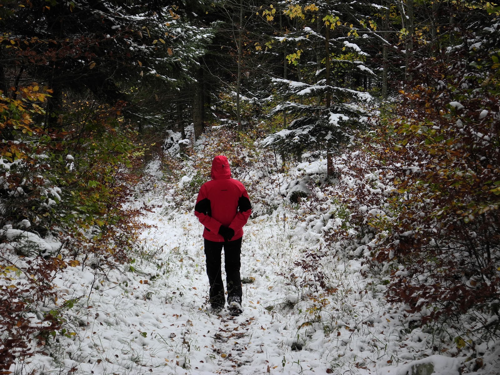
The trail led us deeper and deeper into the forest, and slowly up the hillside towards the "St George refuge". The trail was magnificently soft underfoot, dampened-down by millions of fallen leaves, and about 10 centimetres of snow. It was magical. Snowflakes were still drifting down through the trees, and occasionally a mass of accumulated snow would tumble out of an overhanging branch. We were having fun.

Lis heading into the Mont Chaubert forest.
As usual, I stopped and took a photograph of just about everything. There were lots of interesting shapes formed by snow accumulating on branches, leaves and even whole trees. I discovered a beautifully-fashioned woodpecker hole, which just had to be recorded.

A very neat looking woodpecker hole.

Patterns of snow on autumn leaves.
It's hard to believe that this forest was once part of a working farm - virtually completely cleared for cattle pastures a couple of centuries ago. A certain Monsieur de Gingins d'Elépens established a farm here in 1820. It was subsequently purchased by the Canton of Vaud, in 1837 (on the 28th of December to be precise), and turned over to forestry and aligned industry. Now it is a dense, mixed forest full of predominantly fir, beech, birch and oak. If we were lucky, we were hoping to see some deer, or chamois, or perhaps even some wild boar. We got our hopes up when we came across some fresh deer tracks that came onto, and then followed, our trail. However, unfortunately we didn't catch-up the deer, and soon arrived at the refuge.

Arriving at the St George refuge.
This is an amazingly civilized refuge, all set-up with tables and bench seats, kerosene lamps, candles, barbecue, utensils, and even a cabinet with wine glasses. The wood is all chopped and stacked, and someone has even left dry paper and matches. Too Swiss!!!

Lis outside the front of the St George refuge.
Despite all of the attractions of these amenities and this orderliness, the best thing about the refuge is outside - the magnificent panorama - which provides great views over the nearby Jura Mountains (especially down towards La Dole), the village of St George, and the distant Lac Léman, Geneva and the southern Alps. Unfortunately, not much of the latter was on show, but the village sure looked magnificent down below us, under its mantle of fresh snow.

St George, nestled in the foothills of the Jura below Crêt de la Neuve.
St George is situated at about 940 metres above sea level, on one of the main routes over the Jura Mountain range - via the Col du Marchairuz. The commune is still mostly forest (about 75 per cent), with much of the remainder given over to farmland. The first written mention of the village dates back to 1153 when it was called Sancti Georgii in Essartinis by the resident Benedictine monks. With the conquest of Vaud by the bailiffs of Berne (in 1536), the local priory was secularized, and Saint-George, as it became known, came under the administration of the Bailiwick of Morges. After the collapse of the "ancien regime" (as a result of the "Vaudois Revolution" in 1798), the village came under the control of the Canton of Geneva. (It remained so for the duration of the "Helvetic Republic" period - from 1798 to 1803). With the signing/enactment of the "Constitution Mediation", it found itself transferred to the newly formed Canton of Vaud (within which it remains today). In 1798 it was assigned to the District of Aubonne. It's a great little village.

Lis checking out the magnificent views from the refuge.

Jura peaks La Barillette, La Dôle and Point de Poele Chaud on the horizon above St George.

Somewhere down at the end of Lac Léman (hidden in the mist) lies Geneva.

An arms-length self portrait at the St George refuge.
From the refuge we headed northeast, back into the forest, armed with our GPS, and looking for the nearby summit of Mont Chaubert. With the fresh overnight snow, it was often hard to exactly see where the trail was going, but most of the time the green and white markers on the trees made it easy going (and the GPS, even easier).

Lis near one of the trail marker trees.

Christmas trees in October???
Although it was somewhat difficult to find, being a couple of hundred metres off the trail and partially obscured by dense forest, we soon managed to scramble our way to the top of Mont Chaubert (1082m). It's not much of a summit, so we stayed just long enough to snap a not-so-decisive-moment commemorative photograph ... and then we were gone.

Not exactly the most prominent peak in the Jura - the top of Mont Chaubert.
We retraced our steps back down the slope to the trail, and then continued on our way deeper into the forest. It sure was a lovely place to be walking on a Sunday afternoon.

Above and below: Lis on the trail through the forest.

We passed a few sign-posted landmarks and interesting features - including the "Muraille de Chine" (the Wall of China), a high limestone rock wall of "mysterious" origins, (was it natural, was it man-made?), that was now just a big white blob of snow. A little further on we apparently encountered the ruins of an old mid-19th century farmhouse ("L'ancien chalet d'alpage") - which were impossible to distinguish under the snow and amid the undergrowth.
Fortunately the next landmark was much easier to recognize - the old farmhouse at Mont Bailly (1057m). The farm is still in operation - in a small alpage (mountain pasture) clearing about a kilometre northeast of Mont Chaubert. Mont Bailly (incorrectly marked as Mont Bally on some maps), gets its name from the Bailiffs of Berne (Bailiffs = Bailly) who had the run of the land here about four or five hundred years ago. After the "Vaudois Revolution" in 1798, when the Bernese were evicted from the district, the pasturages came under the control of the City of Lausanne - until the Canton of Vaud was constituted in 1803. More recently, in February 2007, the old farm (with its farmhouse dating back to 1803) was purchased by the nearby village of Gimel.

The old farmhouse at Mont Bailly.
Not surprisingly, it was deserted on the day that we were there, with no signs of life other than a couple of old horses scratching away in the snow trying to find some grass to eat. Adding the only splash of colour to an otherwise monochromatic landscape, a red and white Swiss flag fluttered from a flagpole at the front of the house.

We took a couple of photographs, then quietly watched a lovely, healthy-looking, bushy-tailed fox sniff his way across the snowscape, following the scent of something obviously desirable. He was a magnificent specimen, with a white tip at the end of his bushy tail.

We headed back into the forest, briefly following a ski du fond (cross-country ski) trail, which took us past a mid-19th century silviculture plantation and, soon after, the ruins of the original Mont Chaubert farm.

Lis on the ski du fond track.
The old farmhouse is long gone, but in its place one now finds the Refuge Forestier du Mont Chaubert (1044m), built by local foresters in 1906.
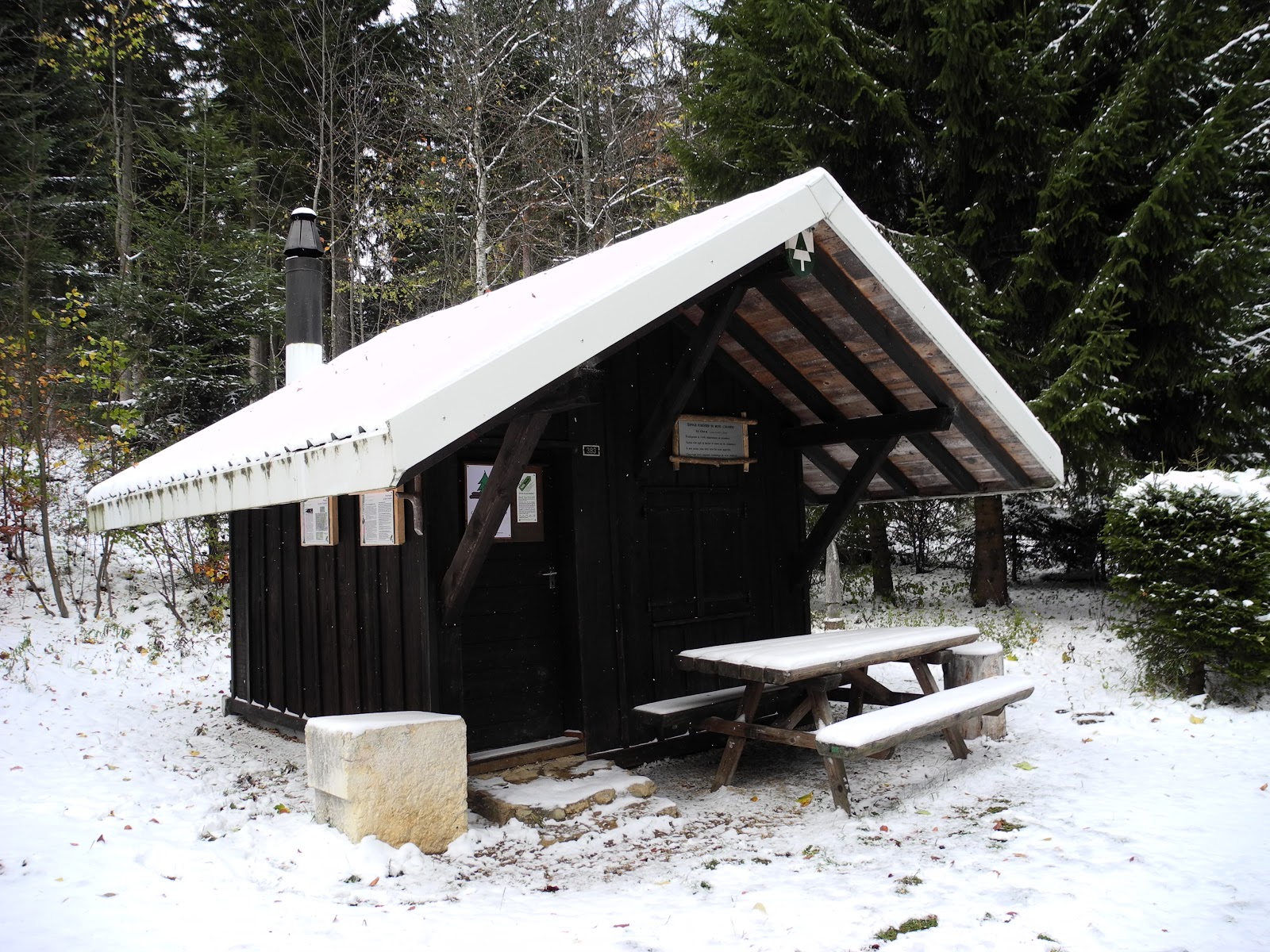
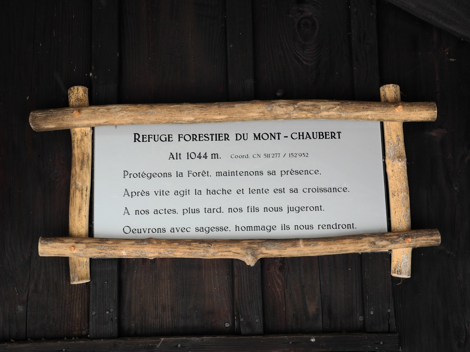
The Refuge Forestier du Mont Chaubert.
The refuge had a neat-looking sign on the front wall with a poem that read:
"Protect the forest, maintain its presence.
After the axe is fast and the growth is slow.
Of our acts, our sons will judge us.
Let us work with wisdom, honoured they will return."
Not a bad mission to greet you when you come to work in these forests, today, and the years into the future.
From the refuge, we headed down a forest trail that more-or-less followed a contour above Côte Viri - the hillside just to the east of la Côte Malherbe. We knew this track well, and knew that we were now close to home, so were savouring the last stages of our loop around the forest trails of Mont Chaubert.
Lis enjoying the last, downhill section of the trail.
We passed the familiar sign designating the entrance to the community forest, and were soon "back in civilization" - at the eastern end of our road - the Chemin de la Côte Malherbe. From there, it was an easy walk home. Not a bad trail to have right on one's doorstep huh?

Jura peaks bagged:
- Mont Chaubert (No. 347) 1082m

No comments:
Post a Comment